Escuela de Primavera 2022
Escuela de Primavera 2022
Sensado remoto avanzado y sistemas espaciales
La escuela de primavera IG 2022, a desarrollarse de manera híbrida durante la última semana de septiembre, es una gran oportunidad para tomar contacto con profesionales de diversas partes del mundo y conocer los últimos desarrollos en materia de técnicas de sensado remoto avanzado, software y plataformas de computación en la nube, nuevas misiones y sistemas satelitales.
Modalidad del evento
Se desarrollará en modalidad híbrida, es decir, habrá oradores y participantes tanto en modo presencial como virtual. Para el modo presencial, que se llevará a cabo en el aula de posgrado de la Facultad de Ciencias Económicas de la Universidad Nacional de Córdoba, en Ciudad Universitaria. Habrá un cupo de 40 personas. Al momento de inscribirse, se solicitará elegir la modalidad de asistencia.
Fecha – del 26 al 30 de Septiembre
Objetivos del evento
Que las personas participantes tomen contacto con el estado del arte y los últimos desarrollos en materia de sensado remoto avanzado y sistemas espaciales: big data en teledetección, software y plataformas de procesamiento en la nube, algoritmos de detección de cambios en series de tiempo, implementacion de sistemas operativos de monitoreo ambiental basados en sensado remoto, datos analysis-ready e instrumentación de técnicas de machine learning en sistemas automáticos, nuevas misiones y aproximaciones a datos hiperespectrales, aplicaciones de la teledetección hiperespectral y, misiones, desafíos tecnológicos y aplicaciones de los cubesats.
Que las personas participantes puedan realizar ejercicios y acceder a experiencia de primera mano en los temas anteriores.
Perfil de quienes participan
Se espera que las personas que se inscriban y participen del evento cuenten con un nivel de Inglés igual o superior a A2 de modo que puedan aprovechar las charlas y contenidos que se abordarán en el transcurso de la semana. Por otra parte, se espera también un nivel básico-intermedio de conocimientos de lenguajes de programación (Python, R, JavaScript) y teledetección, dado que no se enseñarán conceptos introductorios durante las charlas y ejercicios.
Agenda
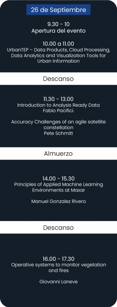
- Apertura del evento de a cargo de representantes de las instituciones organizadoras
- UrbanTEP – Data Products, Cloud Processing, Data Analytics and Visualization Tools for Urban Information
Felix Bachofer
Department of Land Surface Dynamics. Earth Observation Center (EOC). German Aerospace Center (DLR).
Urbanization and sustainable settlement growth are key global challenges. They are closely linked to socio-economic development and affect the surrounding environment, as well as the health of a majority of the global population. Earth observation (EO) information products and other spatial datasets have been successfully used and exploited in this context by many research projects, as well as planning and decision-making processes for making cities more sustainable and resilient. While most of these activities were based on solitary and effortful processing and visualization solutions, platform-based initiatives have proven to be game changing technologies, which are capable of revolutionizing service provision, workflows and information products. The Urban Thematic Exploitation Platform (UrbanTEP; urban-tep.eu) is a collaborative system, which focuses on the processing of EO and other spatial information products for delivering multi-source information on trans-sectoral urban challenges on various scales.
UrbanTEP is developed to provide end-to-end and ready-to-use solutions for a wide spectrum of users (i.a. service providers, expert and non-expert users and researchers) for extracting unique information and products required in the urban context. The key system components are an open, web-based portal connected to distributed and scalable high-level computing infrastructures and providing key functionalities for: i) high-performance data access and processing (IaaS – Infrastructure as a Service), ii) modular and generic state-of-the art pre-processing, analysis, and visualization tools and algorithms (SaaS – Software as a Service), iii) customized development and sharing of algorithms, products and services (PaaS – Platform as a Service), and iv) networking and communication.
The processing, analysis and visualization of EO data in the frame of the New Urban Agenda (NUA) and the Sustainable Development Goals (SDGs) monitoring, specifically the SDG 11 “Sustainable Cities and Communities”, are central aspects of UrbanTEP. Via the concept of the “City Data Cubes” for urban use cases and hosted processing on the DIAS platforms, UrbanTEP offers capabilities to exploit large EO archives (e.g. Copernicus Sentinel missions). EO-based information products support these analyses. The data analytics and visualization capabilities of UrbanTEP provide functionalities for a user-driven derivation of key urban indicators based on the above-mentioned multi-source data collections.
- Introduction to Analysis Ready Data
Fabio Pacifici, Distinguished Scientist, R&D
Maxar Technologies
For users of satellite data, the most time-consuming part of image analysis is adjusting the pixels into a readily usable format. Analysis-Ready Data (ARD) is a workflow designed to minimize the time involved to derive answers from pixels, and it is designed around common pre-processing tasks that generally include atmospheric compensation, orthorectification, pansharpening, color balancing, bundle block adjustment, and grid alignment. The final ARD product consists of a time-series stacks of images that are aligned and produced with a common standard, increasing usable content via localized metadata, more accurate feature extraction, faster processing, lower storage costs, and homogenized inputs for analytic workflows. This presentation introduces the basics concepts of the ARD workflow and the need for standardized data.
- Accuracy Challenges of an agile satellite constellation
Pete Schmitt
Maxar Technologies
Sub meter imagery has been commercially available for the past twenty years. The accuracy of commercial satellite images depends in part on the quality of digital terrain models. Recent improvements to surface models and digital terrain models have increased the accuracy of pixel georegistration. What can be done with a deep stack of co-registered tiles on a fixed grid? I will discuss the accuracy of Maxar’s Analysis Ready Data and show examples how a deep temporal stack of imagery can be used for feature extraction and look at the results of a cloud free mosaic prototype.
- Principles of Applied Machine Learning Environments at Maxar
Manuel Gonzalez-Rivero
Director Of Applied Machine Learning – Maxar Technologies
Companies that create Machine Learning solutions for real world problems requires a high degree of technical coordination between production teams, data providers, Data Scientists, Machine Learning Engineers, ML Operations engineers, and subject matter experts. With daily data acquisition pipelines that bring in tens of terabytes a day and real time daily operations timeline requirements, Maxar is no exception. During this discussion, we will talk about the technology architectures that enable this technical coordination and a model training exercise with Maxar’s Applied Machine Learning platform using real data. We will also discuss where we think the future of remote sensing lies with respect to deep learning driven remote sensing at Maxar.
- Operative systems to monitor vegetation and fires
Giovanni Laneve
Scuola di Ingegneria Aerospaziale. Sapienza Università di Roma.
The seminar aims at presenting state-of-the-art satellite based procedures to monitor vegetation status for providing daily updated maps of the spatial fire hazard distribution and monitor active fires by using multi-point geostationary satellites. The characteristics of the tools (based on MATLAB, Python, gdal) adopted to provide operational products/services to support the three phases (prevention, monitoring and damage assessment/restoration) involved in the management of forest fires, will be illustrated. The description of the products/services will also consider the potential improvement achievable by exploiting the next generation of EO observation systems.
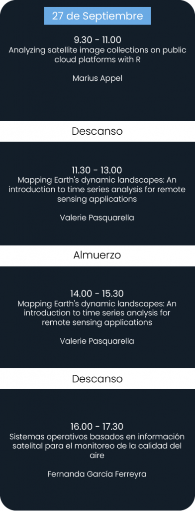
- Analyzing satellite image collections on public cloud platforms with R
Marius Appel
University of Münster, Institute for Geoinformatics
This tutorial demonstrates how to access and process satellite image collections on cloud computing platforms using R and modern cloud-native tools including SpatioTemporal Asset Catalogs, cloud optimized GeoTIFFs, and on-demand data cubes. After a quick introduction and overview of corresponding R packages, practical examples on image compositing, time series analysis, and the extraction of training data for machine learning models will be presented in a live demonstration. The tutorial will end with a discussion of limitations and future developments in R. Materials and further information will be published at: https://github.com/appelmar/CONAE_2022.
- Mapping Earth’s dynamic landscapes: An introduction to time series analysis for remote sensing applications
Valerie Pasquarella
Harvard Forest / Google
Our planet is constantly changing as a result of ecological and socioeconomic interactions across a variety of spatial and temporal scales. A growing number of Earth observation datasets provide regularly repeated synoptic measurements that enable us to map and understand landscapes as the dynamic systems they are. In this session, we’ll explore several approaches for detecting and characterizing changes in land cover and condition, including spectral anomaly detection using harmonic baseline models, the LandTrendr and Continuous Change Detection and Classification (CCDC) temporal segmentation algorithms, and Dynamic World, a new continuously updating per-image classification dataset. We’ll review general mechanics and use cases for these different approaches and participants will have opportunities to experiment with algorithms and workflows for their own study systems.
- Sistemas operativos basados en información satelital para el monitoreo de la calidad del aire
Fernanda García Ferreyra
Instituto Gulich (UNC-CONAE). Comisión Nacional de Actividades Espaciales, CONAE
Los contaminantes atmosféricos pueden presentar un riesgo para la salud humana directa o indirectamente. Por ello, el monitoreo sistemático de contaminantes atmosféricos es necesario para la definición de regulaciones regionales de calidad de aire. En los últimos años, los sensores satelitales han ganado importancia como herramienta para la evaluación y monitoreo de la contaminación atmosférica en el mundo, complementando la información obtenida por estaciones de monitoreo de superficie.
En esta ocasión se presentan experiencias de investigación y desarrollo para dar respuesta a usuarios con diferentes requerimientos sobre el monitoreo ambiental y de distintas instituciones públicas que se vinculan con la CONAE. Así, llevamos adelante trabajos de implementación de productos operativos para el monitoreo sistemático de la contaminación del aire y su evaluación, utilizando herramientas de la teledetección satelital y del modelado atmosférico.
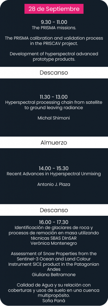
- The PRISMA mission
Ettore Lopinto
ASI
PRISMA, in orbit since March the 22nd 2019, opened the user access two and half years ago, in spring 2020. Recently we break-out the one-thousand five-hundreds threshold of user accounts, which witness the high worldwide interest into this innovative mission.
PRISMA is a hyperspectral mission based on a single small class spacecraft, placed on a frozen sun-synchronous orbit with a repeat cycle of 29 days. The Payload is based on an electro-optical instrument composed of a high spectral resolution spectrometer optically integrated with a panchromatic camera. It records the radiation reflected from the Earth surface (spectral cubes) in the 400nm – 2505nm spectral window with 239 bands in VNIR/SWIR wavelength range plus a single PAN band. The imaging spectrometer covers the nominal 400-2500 nm spectral range with a spectral sampling interval better than 14nm with 12-bit radiometric quantization. Geometric accuracy of products is 200m CE90 and 15m CE90 respectively without and with Ground Control Points. Absolute HYP radiometric accuracy is better than 5%. Mission revisit time is 29 days at the same look angle (orbital cycle) but <7days with variable looking, with an average response time of 7.5 days. Images can be acquired worldwide.
Access to mission capabilities is realized through the WEB portal https://prisma.asi.it/ in which the user can ask registration and once the registration is accepted, he can either program new acquisitions or download products from the archived images all over the world’s land. These products can be obtained free of charge and with a quasi-open policy.
The first 24 months of mission usage by the user community have seen in the (statistically) most representative part of the user population, the following figures:
- 15 nations cover 80% of the users
- the Italian users are only 1/4
- India, USA, Germany and China together account the 1/3 of the users
- 64% of the total users are scientists (52% of the users belongs to non-Italian Science and is the largest category)
- Institutional (9%) and commercial (11%) represents 20% of total users
- Foreign commercial (8%) is two times the Italian commercial (4%)
- 6% of users are still freelance!
- 32 thematic areas cover 70% of all applicative usages
- 164k images acquired (at mid June 2022)
- The PRISMA calibration and validation process in the PRISCAV project
Federico Carotenuto
National Research Council of Italy
The seminar will discuss the insights and results from the PRISMA satellite calibration and validation project (PRISCAV). It will introduce the methods and procedures applied to the satellite’s ground truthing measurements on the project’s fiducial reference sites spanning multiple land and water types and will show the results of the comparison between level 2 satellite data versus in-situ data. The presentation will sum up overall PRISMA performances as well as introducing important concepts for space-to-ground data comparisons. Furthermore, these concepts will be extended to consider ground-truth upscaling via comparions with hyperspectral airborne data collected by aircrafts during dedicated sampling campaigns.
- Development of hyperspectral advanced prototype products
Alessia Tricomi
e-GEOS S.p.A.
Bio: Alessia Tricomi is a Remote Sensing Data Scientist and Python Developer at e-GEOS in the Product Development and Innovative Services Unit. She is an expert in applications for agriculture and land monitoring/classification based on multispectral and hyperspectral data.
- Recent Advances in Hyperspectral Unmixing
Antonio J. Plaza
Hyperspectral Computing Laboratory (HyperComp). Department of Technology of Computers and Communications. Escuela Politécnica de Cáceres, University of Extremadura
Spectral unmixing is an important technique for remotely sensed hyperspectral data exploitation. In this presentation, new advances in spectral unmixing will be discussed, including different algorithms for linear spectral unmixing based on endmember (pure signature) extraction, use of spectral libraries for sparse unmixing of hyperspectral data, nonlinear spectral unmixing, and high performance implementations of unmixing algorithms in specialized computing platforms such as clouds, GPUs and FPGAs.
- Hyperspectral processing chain from satellite to ground leaving radiance
Michal Shimoni
Head of Applications. Kuva Space. Espoo, Finland
A hyperspectral combines imaging and spectroscopy into a single optical system that can record hundreds of spectral bands, with relatively narrow bandwidths (5-10 nm), from satellites to measure radiance leaving the Earth’s surface. By capturing the spectral signature in each image pixel, the system can identify objects, changes, materials, monitor contamination, or determine atmospheric trends that would otherwise be invisible to the human eye. However, the retrieval of accurate spectral data requires careful pre-processing utilizing an automated, consistent and standardized process chain. As a result of recent technological advancements, large hyperspectral satellites with weekly and monthly revisits have been consolidated into constellations of small satellites with a daily revisit, a novel integrated spectral selection technologies, scanning modes and miniature cameras. The new acquisition methods impose new challenges on the pre-processing architecture designed to determine the measured surface reflectance values within each image pixel from the acquired raw data. This talk provides an overview of the benchmarks and new trends in image enhancement, radiometric correction, georectification, orthorectification, and atmospheric correction methods needed to retrieve surface leaving radiance. It discusses different modes of acquisition along with relevant solutions toward quality processing chains.
- Identificación de glaciares de roca y procesos de remoción en masa utilizando técnicas SBAS DInSAR
Verónica Montenegro
La interferometría de radar de apertura sint ́etica (InSAR) es una técnica muy utilizada para medir desplazamientos de la superficie terrestre (a lo largo de la línea de visión sensor-objetivo), en grandes ́areas a partir de dos o más imágenes (SAR). En este trabajo, se presentan los resultados obtenidos durante la estadía realizada en el primer semestre de 2022 en el instituto CNR-IREA (Institute for Electromagnetic Sensing of the Environment), Napoles, Italia. El objetivo principal de esta pasantía fue la aplicación de técnicas de interferometría multitemporal SBAS para identificar glaciares de roca y procesos de remoción en masa en el noroeste de la Argentina. Se utilizaron imágenes Sentinel-1 (banda C) del periodo 2020-2021, tanto en geometría ascendente como descendente, con las cuales se obtuvieron mapas de velocidad finales, que sirven de base para la realización de inventarios de estas geoformas en el área de estudio.
- Assessment of Snow Properties from the Sentinel-3 Ocean and Land Colour Instrument SICE product in the Patagonian Andes
Giuliana Beltramone
Becaria doctoral CONICET. Instituto Gulich (CONAE – UNC)
Seasonal snowpacks in the Patagonian Andes are the primary source of surface runoff and water supply in the adjacent lowlands, and represent a critical resource for local domestic consumption, irrigation, industries, weather forecasts, among other applications.
Changes in snow cover extent are predominantly linked to changes in meteorological conditions. However, snowpacks are also influenced by the impact on the snow albedo of Light-absorbing Impurities that may accelerate the effect that higher temperatures produce on the cryosphere.
Considering the spatial coverage of snowpacks, their temporal variability, and inaccessibility, remote sensing is an ideal data acquisition technique for monitoring snow cover and its trends on both spatial and temporal scales.
Important snow parameters such as albedo, and grain size, have been lately derived and validated in Antarctica, Greenland and the French Alps. These 300m spatial resolution products were achieved with Sentinel-3 – OLCI (Ocean and Land Colour Instrument) images, together with the development of the SICE (Snow and Ice optical properties) processing chain.
In this work, in situ albedo measurements from Automatic Weather Stations from Chile were compared with the SICE albedo product, with the objective of validating this parameter in the Patagonian Andes. Validation metrics such as RMSE, MAPE, R2, and BIAS were used in order to assess the SICE albedo product accuracy.
- Calidad de Agua y su relación con coberturas y usos de suelo en una cuenca multipropósito.
Sofia Paná
Becaria doctoral CONICET. Instituto Gulich (CONAE – UNC)
La pasantía se desarrolló durante 6 meses en el Laboratorio de Ecología del Paisaje. Durante este período se analizó la distribución y los cambios en la calidad del agua del río Suquía (Córdoba, Argentina) y su relación con los patrones de uso y cobertura del suelo de la cuenca mediante técnicas de teledetección y un enfoque estadístico. Se comparó el LULC a nivel de la cuenca del Suquía en 2 momentos en el tiempo (1997-1998/2018-2019) y se determinó la calidad del agua para estos dos períodos en diferentes puntos de muestreo a lo largo del río utilizando un Índice de Calidad del Agua. Se analizaron estadísticamente las relaciones entre los usos y coberturas del suelo en diferentes zonas de amortiguación y el Índice de Calidad del Agua. También para el periodo 2018-2019 se evaluó la relación entre el Índice y el LULC estacional de los cultivos. Se llevó a cabo además un Análisis de Componentes Principales y un Análisis de Clústeres para identificar fuentes de contaminación relativas al río. Los primeros resultados indican que la calidad del agua del río Suquía está influenciada por impactos antropogénicos a escala de la cuenca, principalmente generados por la agricultura y la planta de tratamiento de efluentes de Bajo Grande.
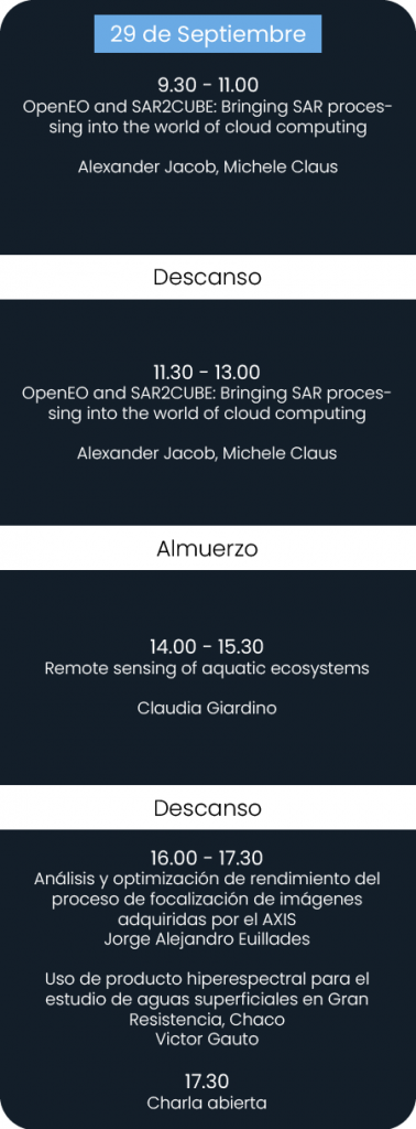
- OpenEO and SAR2CUBE: Bringing SAR processing into the world of cloud computing
Alexander Jacob, Michele Claus
Eurac Research – Institute for Earth Observation, Viale Druso 1, 39100 Bolzano, Italy
During the workshop we will introduce the openEO API and some examples of its implementation in Europe based on the developments carried out in the ESA SAR2CUBE and openEO platform projects. OpenEO is a very modern high-level API aiming at defining EO processing workflows independent from the infrastructure in which they are processed. It is based on the concept of virtual data cubes and the chain ability of operations that can be called on those data cubes. Many data cubes have been developed recently, but very few have tackled the difficulties of working with complex data in the Slant-Range geometry. In the SAR2CUBE project a framework for defining SAR data cubes in their natural format and make them compatible with other geo-projected raster data has been developed. Both projects are completely based on open-source technology and are continued to be developed as open source. SAR2CUBE makes use of the openEO API to expose the newly defined processes specifically for working with SAR data.
- Remote sensing of aquatic ecosystems
Claudia Giardino
National Research Council of Italy
Institute for Electromagnetic Sensing of the Environment (CNR-IREA)
This talk will present an overview of EO technology in support to water quality monitoring with specific applications on lakes and freshwater reservoirs. The presentation will show the state-of-the-art of methods which have been commonly applied in the last years to tune satellite data into user ready products. Examples on integration of satellite-derived products to field measurements and modelling for supporting end-users needs will be presented. A relevant part of the talk will be dedicated to PRISMA (PRecursore IperSpettrale della Missione Applicativa), the hyperspectral satellite sensor of the Italian Space Agency (ASI) in orbit since March 2019, which might also provide valuable data for water quality mapping.
- Uso de producto hiperespectral para el estudio de aguas superficiales en Gran Resistencia, Chaco
Victor Gauto
En el Área Metropolitana del Gran Resistencia hay gran presencia de lagunas; el río Negro y el riacho Barranqueras atraviesan la región y el río Paraná, al Este, poseen grandes efectos en la distribución y tamaño de estos cuerpos de agua, junto con las lluvias y períodos de sequía. La teledetección satelital, mediante sensores ubicados en plataformas satelitales, ofrece una extensa cobertura espacial y temporal. En el NEA argentino, la aplicación de esta tecnología es escasa. Se tomaron siete sitios muestrales en diferentes aguas superficiales, representando tres tipos de agua. Se obtuvieron las firmas espectrales dadas por el sensor multiespectral MSI a bordo de la plataforma Sentinel-2 (Agencia Espacial Europea) y el sensor hiperespectral de la misión PRISMA (Agencia Espacial Italiana). Se compararon diferentes productos: reflectancias de superficie, con corrección atmosférica automática y manual mediante el software ACOLITE; y reflectancia a tope de atmósfera para las diferentes clases de agua. Se calcularon métricas de error para estimar los desvíos entre PRISMA y Sentinel-2. Para estudiar las características del río Paraná, se ubicaron diez puntos muestrales a lo largo de una transecta, se llevó a cabo un análisis espectral y cromático. Con ACOLITE se obtuvieron estimaciones de parámetros fisicoquímicos del agua para explicar las firmas espectrales.
- Análisis y optimización de rendimiento del proceso de focalización de imágenes adquiridas por el AXIS
Jorge Alejandro Euillades
Los sistemas de Radar de Apertura Sintética (SAR) aerotransportados resultan de gran interés debido a su flexibilidad operativa y sus capacidades de observación. Entre estos sistemas, aquellos que utilizan la tecnología de Onda Continua Modulada en Frecuencia (FMCW) dan lugar a dispositivos compactos, livianos y de bajo costo. Por ello, se han vuelto muy atractivos ya que pueden ser fácilmente montados sobre plataformas aéreas cada vez más pequeñas y flexibles, tales como helicópteros o drones. Un sistema basado en la tecnología FMCW y diseñado para aplicaciones interferométricas es el AXIS, el cual ha sido desarrollado en el marco de un acuerdo de cooperación entre el instituto IREA-CNR (Italia) y la compañía Elettra Microwave S.r.l. La focalización de datos adquiridos por sistemas aéreos requiere de utilizar algoritmos que incorporen procedimientos de compensación de movimientos para mitigar aberraciones introducidas en las señales de radar. Con el fin de preservar la calidad de las imágenes enfocadas, se suelen utilizar algoritmos implementados en el dominio del tiempo, los cuales resultan costosos a nivel computacional y consumen un tiempo considerable.En el trabajo realizado se analizan distintas estrategias para incrementar la eficiencia del proceso de focalización de imágenes en sistemas aerotransportados, específicamente para el AXIS.
- Charla abierta
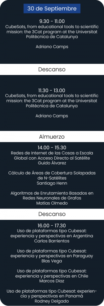
- CubeSats, from educational tools to scientific mission: the 3Cat program at the Universitat Politècnica de Catalunya
Adriano Camps
CommSensLab-UPC, Dept of Signal Theory and Communications, Universitat Politècnica de Catalunya and Institut d’Estudis Espacials de Catalunya; 08034 Barcelona, Spain
The Universitat Politècnica de Catalunya UPC NanoSat Lab is part of the CommSensLab-UPC Specific Research Center of the Department of Signal Theory and Communications, and counts with the support of the School of Telecommunications Engineering (Telecom Barcelona, ETSETB). It is located in the UPC Campus Nord. The lab was originally created in 2007 to promote the testing of novel remote sensors and techniques in space, taking advantage of CubeSats. Over time, the lab has also started the study of Earth-to-space IoT and RF intersatellite link communications, as key enabling technologies for the next revolution of Earth Observation. The UPC NanoSat Lab has developed and launched four CubeSats, and is working in three new missions that will be launched in Q1-Q2 2023. At present, the Lab is also developing an “Open PocketQube Kit” for IEEE as a low-cost educational platform on space-related technologies. The lab has also a Class 8 clean room equipped with a shaker and thermal vacuum chamber, and Helmholtz coils, air bearing system, and Sun simulator for attitude determination and control system testing to conduct the environmental tests [https://nanosatlab.upc.edu/en].
Finally, in the MontSec Astronomical Observatory (OAdM),which is managed and operated by IEEC, hosts the UPCNanoSat Lab VHF/UHF and S-band ground station, where the data from the 3Cat-5/A satellite where downloaded. Since its inception in 2007, about 300 students have been trained in the lab, either as undergraduate students in the “Advanced Engineering Project” of the ETSETB, as Final Degree or Master Thesis projects, as graduate students, or just for an internship. This paper presents a quick overview of the past, present and future activities of the UPC NanoSat Lab, fully conducted using undergraduate and PhD students, as well as some of the lessons learned over the past 15 years.
- Redes de Internet de las Cosas a Escala Global con Acceso Directo al Satélite
Guido Álvarez
Unidad de Formación Superior, Comisión Nacional de Actividades Espaciales (CONAE), Argentina
Existe un gran interés en sistemas de Internet de las Cosas (IoT) satelital con acceso directo a satélite. Gracias a las bajas tasa de datos y escasos recursos característicos de este tipo de comunicación, es un excelente candidato para ser implementado en plataformas tipo CubeSat. En esta charla presentamos el concepto, sus beneficios y oportunidades de aplicación.
- Cálculo de Áreas de Cobertura Solapadas de N-Satélites
Santiago Henn
Consejo Nacional de Investigaciones Científicas y Técnicas (CONICET), Argentina
El uso de plataformas tipo CubeSat permite escalar la cardinalidad del segmento de vuelo a N satélites. Sin embargo, los métodos para realizar un estudio de área de cobertura con N satélites son limitados y requieren del análisis de múltiples puntos en la superficie terrestre. En esta charla introducimos un nuevo algoritmo para calcular el área de cobertura de N satélites, mostrando sus beneficios y oportunidades de aplicación.
- Algoritmos de Enrutamiento Basados en Redes Neuronales de Grafos
Matías Olmedo
Unidad de Formación Superior, Comisión Nacional de Actividades Espaciales (CONAE), Argentina
Contar con una red interconectada en vuelo es factible gracias a los bajos costos de las plataformas tipo CubeSat. Sin embargo, la conectividad esporádica y los recursos de cómputo en vuelo son escasos. En esta charla presentamos un método de enrutamiento basado en técnicas de machine-learning. Mostramos que un grafo adecuadamente entrenado de redes neuronales puede entregar resultados satisfactorios a una fracción del esfuerzo de cómputo.
- Uso de plataformas tipo Cubesat: experiencia y perspectivas en Argentina
Carlos Barrientos
Unidad de Formación Superior, Comisión Nacional de Actividades Espaciales (CONAE), Argentina
El uso de plataformas tipo Cubesat permite contar con una manera rápida y efectiva para probar en vuelo instrumentos satelitales de diferentes características. Esta tecnología provee una promisoria relación costo-beneficio y permite reducir el riesgo técnico y programático. En esta charla mostraremos la experiencia ganada en proyectos previamente encarados y las perspectivas a futuro.
- Uso de plataformas tipo Cubesat: experiencia y perspectivas en Paraguay
Blas Vega
Agencia Espacial del Paraguay. Paraguay.
El uso de plataformas tipo Cubesat permite contar con una manera rápida y efectiva para probar en vuelo dispositivos de diferentes características. Esta tecnología provee una promisoria relación costo-beneficio y permite reducir el riesgo técnico y programático. En esta charla mostraremos la experiencia ganada en proyectos actualmente en curso y las perspectivas a futuro.
- Uso de plataformas tipo Cubesat: experiencia y perspectivas en Chile
Marcos Diaz
Laboratorio de Exploración Espacial y Planetaria, Universidad de Chile, Chile.
El uso de plataformas tipo Cubesat permite contar con una manera rápida y efectiva para probar en vuelo dispositivos de diferentes características. Esta tecnología provee una promisoria relación costo-beneficio y permite reducir el riesgo técnico y programático. En esta charla mostraremos la experiencia ganada en proyectos actualmente en curso y las perspectivas a futuro.
- Uso de plataformas tipo Cubesat: experiencia y perspectivas en Panamá
Rodney Delgado
Programa de Utilización del Espacio para el Desarrollo Nacional. Universidad Tenológica de Panamá, Panamá.
El uso de plataformas tipo Cubesat permite contar con una manera rápida y efectiva para probar en vuelo dispositivos de diferentes características. Esta tecnología provee una promisoria relación costo-beneficio y permite reducir el riesgo técnico y programático. En esta charla mostraremos la experiencia ganada en proyectos actualmente en curso y las perspectivas a futuro.
Cronograma
ACLARACIÓN
El día 30 de septiembre la modalidad será unicamente virtual.
Disertantes

Dr Michal Shimoni is an awarded scientific expert in the field of hyperspectral with extensive experience implementing spectral imaging in various applications. She was appointed by NATO as an expert of hyperspectral technology in May 2022 and currently works as Head of Applications at Kuva Space, coordinating the development of products and services.

Alexander Jacob coordinates the research group Advanced Computing for Earth Observation, within the Institute for Earth Observation at EURAC Research. He is an expert in earth observation and data science and is currently working on standardizing and improving access to cloud processing facilities and organization of earth observation data into data cubes.

Antonio Plaza is a Full Professor and the Head of the Hyperspectral Computing Laboratory at University of Extremadura, where he received the M.Sc. degree in 1999 and the PhD degree in 2002, both in Computer Engineering. His main research interests comprise hyperspectral data processing and parallel computing of remote sensing data.

Dr. Felix Bachofer is Head of the research team “Coasts and River Basins” at the Earth Observation Center (EOC) of the German Aerospace Center (DLR). He is managing several research projects and investigating urban development, coastal areas, flood and drought, and climate change interrelations using multi-sensor remote sensing.

Fernanda García Ferreyra investiga y desarrolla aplicaciones para el monitoreo satelital y modelado de la calidad del aire, en la CONAE. Es docente de teledetección ambiental del Instituto Gulich.

Giovanni Laneve is an associate professor at the School of Aerospace Engineering of Sapienza University of Rome. He is the scientific responsible of the EOSIAL laboratory (Earth Observation Satellite Images Applications Lab.) devoted to the development of applications based on the exploitation of satellite images.

Giuliana Beltramone es becaria CONICET y realiza el doctorado en Geomática y Sistemas Espaciales del Instituto Gulich (CONAE-UNC). Su tema de tesis se enfoca en la evaluación espacio-temporal del impacto de carbono negro en cuerpos níveos de los Andes patagónicos a partir de información satelital y modelado numérico.

Jorge A. Euillades es becario doctoral de CONICET y su lugar de trabajo es el Instituto CEDIAC. Su investigación está enfocada en el procesamiento de datos SAR para la determinación de desplazamientos utilizando radares FMCW y técnicas interferométricas, y su aplicación en el estudio de deformación cortical.

Manuel Gonzalez-Rivero has spent a career exploring remote sensing, machine learning, data science and computer vision on orbital platforms. He worked at General Dynamics and Lockheed Martin building real time satellite payloads, teaching remote sensing at ARL-PSU, building global machine learning pipelines at Planet Labs. He is now the director of Applied Machine Learning at Maxar.

Marius Appel is a post doctoral researcher in Geoinformatics, interested in all parts of spatial data science, contributing to open source software projects to efficiently process spatiotemporal data in R.

Verónica Montenegro actualmente está realizando la tesis de la Maestría en Aplicaciones de Información Espacial (MAIE) en el Instituto Gulich (CONAE-UNC). Su investigación está enfocada en aplicaciones de Interferometría de Radar de Apertura Sintética para la identificación de glaciares de roca y procesos de remoción en masa. Actualmente trabaja en el área de Desarrolos y Soluciones Ambientales de la CONAE

Víctor Gauto trabaja en el Grupo de Investigación GISTAQ de la UTN Resistencia y es alumno avanzado de la MAIE en el Instituto Gulich. Se interesa en el estudio de cuerpos y cursos de agua interiores, usando imágenes ópticas para estimar sus propiedades mediante algoritmos semiempíricos.
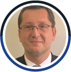
Adriano Camps is a full professor at the Electromagnetics and Photonics Eng. Group, Dept. of Signal Theory and Communications, UPC. He co-leads the Remote Sensing Lab and leads the UPC NanoSat Lab. His research interests are focused in microwave remote sensing, GNSS-R, radio frequency interference, and nanosatellites to test innovative remote sensors.

Michele Claus is a junior researcher at EURAC Research, in the group Advanced Computing for Earth Observation where he deals with satellite big data with the use of python libraries for earth observation, developing tools to improve processing pipelines with parallelization.

Sofía Paná es becaria doctoral CONICET en el doctorado de Geomática y Sistemas Espaciales del Instituto Gulich. Su investigación está asociada a la calidad del recurso hídrico superficial en la cuenca del río Suquía (Córdoba, Argentina).

Paolo Gamba is Professor at the University of Pavia, Italy, where he leads the Telecommunications and Remote Sensing Laboratory. His research is focused on urban remote sensing, data fusion, EO data for physical exposure and risk management. He is highly involved in IEEE-GRSS, having served as Editor-in-Chief of a journal, GRSS President, chair of committees and IGARSS in several opportunities.

Fabio Pacifici has extensive experience in developing geospatial products to bring together the advancements in the satellite industry with the computer vision and artificial intelligence research communities. He is interested in all aspects of remote sensing, including GeoAI, multi-temporal images and data fusion, hyperspectral and synthetic aperture radar data analysis.

Dr. Valerie Pasquarella works at the intersection of remote sensing and ecology and has over a decade of experience using time series of satellite imagery to map and monitor landscape patterns and processes.

Blas Vega es ingeniero de proyectos de la Agencia Espacial del Paraguay. Es ingeniero en electrónica de la Universidad Nacional de Asunción y ha concluido el cursado de la Maestría en Instrumentos Satelitales (MIS) en la UTN-FRM de Argentina. Sus intereses de investigación son los proyectos espaciales, los instrumentos satelitales y la tecnología de instrumentación en general.

Guido Alvarez es investigador en la Unidad de Formación Superior de la Comisión Nacional de Actividades Espaciales (CONAE). Es ingeniero en telecomunicaciones de la UNRC, recientemente ha concluido el cursado de la Maestría en Instrumentos Satelitales (MIS) en la UTN-FRM y es doctorando del Instituto Gulich (DGSE). Sus intereses de investigación son las redes de comunicaciones que permiten Internet de las Cosas (IoT) satelital con acceso directo a satélite.

Santiago Henn es becario doctoral del Consejo Nacional de Investigaciones Científicas y Técnicas (CONICET). Es ingeniero electrónico recibido en la UNC y se ha graduado de la Maestría en Tecnología Satelital (MTS) de la UTN-FRC. Sus intereses de investigación son modelos y algoritmos para el diseño y optimización de misiones espaciales basadas en constelaciones de pequeños satélites.

Matías Olmedo es investigador en la Unidad de Formación Superior de la Comisión Nacional de Actividades Espaciales (CONAE). Es ingeniero electrónico de la UTN-FRC y recientemente ha concluido el cursado de la Maestría en Tecnología Satelital (MTS) en la misma universidad. Sus intereses de investigación son redes de comunicación para proveer interconexión en sistemas espaciales en vuelo y el uso de técnicas de machine-learning para el abordaje de esta temática.
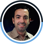
Rodney Delgado es Doctor en Astrofísica. Es docente, investigador y Director Nacional de Ciencias Espaciales de la Universidad Tecnológica de Panamá (UTP). Es además Director General del Proyecto Satelital Panameño PUEDEN: “Programa de Utilización del Espacio para el Desarrollo Nacional”. Ha trabajado en importantes proyectos de investigación en Astronomía y Tecnología, contando con múltiples publicaciones en la materia. Recientemente se ha especializado en la integración y ensamblado de nanosatélites.

Carlos Barrientos es Responsable de la Unidad de Formación Superior de la Comisión Nacional de Actividades Espaciales (CONAE). Es ingeniero nuclear recibido en el Instituto Balseiro y Master of Science del Massachusetts Institute of Technology (MIT). Ha participado en el desarrollo de varias misiones satelitales argentinas, como SAC-A, SAC-C y SAOCOM. Sus principales intereses técnicos son las aplicaciones de la disciplina de ingeniería de sistemas a misiones distribuidas, los instrumentos satelitales y los subsistemas de control térmico.

Pete Schmitt is a Principal Software Engineer at Maxar and has a master’s degree in Applied Mathematics. Pete has developed software for Maxar basemaps and Maxar’s Analysis Ready Data product.

Ettore Lopinto has 30+ years of experience in space projects, acquired both in the management field and in the technical field, mainly in the Earth Observation sector by participating in about 100+ initiatives and activities in the development of systems, applications and ground components of space missions (PRISMA, Italian Sentinel Collaborative Ground Segment).

Federico Carotenuto is a post-doc researcher at CNR -IBE. He is part of the ground team of the PRISMA calibration/validation project (PRISCAV) focused on measuring ground truth on agricultural sites.

Alessia Tricomi is a Remote Sensing Data Scientist and Python Developer at e-GEOS in the Product Development and Innovative Services Unit. She is an expert in applications for agriculture and land monitoring/classification based on multispectral and hyperspectral data.

Marcos Díaz es profesor del departamento de Ingeniería Eléctrica de la Universidad de Chile. Está a cargo del Laboratorio de Exploración Espacial y Planetaria de la Universidad de Chile, donde realiza investigación y desarrollo en el área de la instrumentación para las geo-ciencias con énfasis en la exploración espacial.

Claudia Giardino is research director at CNR-IREA. She has a degree in environmental engineering and PhD in remote sensing sciences from Politecnico di Milano (Italy). She has done R&D activities on remote sensing for inland and coastal waters for 25+ years.
Instituciones que participan




Material para descargar
Inscripción CERRADA
IMPORTANTE:
- El formulario se podrá enviar siempre y cuando se hayan completado todos los campos marcados como «obligatorios».
- Una vez enviado, aparecerá un mensaje confirmando la operación y le llegará por correo electrónico la misma notificación (chequear carpeta «Spam»). En caso de no ocurrir esto último, completar y enviar nuevamente.
- Podrá inscribirse para la modalidad PRESENCIAL en al Escuela de Graduados de Ciencias Económicas de la Universidad Nacional de Córdoba, en Ciudad universitaria (Córdoba) con un cupo de 45 personas, o en modalidad VIRTUAL.
- La certificación que podrá obtener luego de las jornadas es la de workshop o curso de posgrado. En el segundo caso, el cupo máximo a admitir será de 100 personas. La información que se solicita es diferente dependiendo cada caso, por lo que deberá completar únicamente el formulario correspondiente a tal caso.
En la parte delantera del sobre donde envíe toda la documentación debe decir: NOMBRE, APELLIDO Y PROPUESTA EDUCATIVA A LA QUE PERTENECE.
Previamente a enviar la documentación por correo postal debe enviar en PDF una copia de cada documento a enviar al correo cursos@ig.edu.ar
Es obligatorio que todas las documentaciones estén certificadas por Escribano Público Nacional o certificadas por la Apostilla de la Haya SIN EXCEPCIÓN
NO se aceptarán otros tipos de certificaciones.
1) Fotocopia de DNI, CI o Pasaporte: Certificado por escribano público o apostilla de la haya (en caso de ser extranjero)
2) Fotocopia de Analitico universitario (o concentrado de notas): Debe constar claramente la finalización de estudios en el analítico universitario. – Egresados/as de universidades argentinas: Fotocopia certificada por Escribano Público Nacional matriculado. En la fotocopia debe constar claramente la finalización de estudios universitarios. – Egresados/as de universidades extranjeras: Fotocopia certificada mediante Apostilla de la Haya.(La fotocopia debe estar certificada, no se aceptará fotocopia de original certificado.)
3) Fotocopia de Título (Diploma) universitario: si hubiere, certificada por Escribano Público Nacional matriculado (Egresados argentinos) o certificado mediante Apostilla de la Haya (Extranjeros) . IDEM PUNTO 2
4) Currículum Vitae: firmado en todas sus hojas
5) Foto/retrato color formato jpg. 6) Pre Inscripción por Guaraní: – Si ud. ya fue alumno de la UNC/IG: deberá realizar la pre inscripción a la propuesta por autogestión y notificar que se hizo por este medio al correo cursos@ig.edu.ar – si ud. no fue alumno de la UNC/IG: deberá realizar la pre inscripción a la propuesta por preinscripción y enviar el formulario firmado que se genera al finalizar al correo cursos@ig.edu.ar
DESTINATARIO: Instituto Gulich, Universidad Nacional de Córdoba – Secretaria General del Rectorado – Mesa general de entradas y salidas.
DIRECCIÓN: Enrique Barros, esquina Enfermera Gordillo Gomez. Baterías Aulas “D”. EDIFICIO CLAUSTRORUM- CPA 5000, Córdoba Capital, Argentina.